


Geospatial Services
We offer the most complete services
We offer the most complete services
Geospatial Technology is the backbone for most Decision Support Systems being used by various agencies. Location, coordinates, dimensions are critical components for management of land, municipal assets & natural resources.
Connective9 understands the needs of various private and Government agencies, and we covers all aspects of a geospatial and engineering lifecycle – from data capture using remote sensing techniques, to physical survey, along with gathering data, developing custom applications for clients and data maintenance.
Map Digitization & Geo-referencing, Physical, DGPS Surveys, Network Mapping (Road, Railways, Gas & Telecom)
Image Interpretation, Image Processing, Terrestrial Surveys, Imagery Consulting, Modeling, Land based mapping.
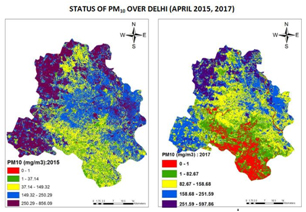
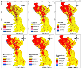
Mining, Agriculture, Forest, Water Quality Mapping, Air Quality Mapping and Modeling, Urban Sprawl and Smart cities
Copyright © 2021 Connective9. all rights reserved.